
What the company publishes
Flock Safety does not release a location list. It publishes a transparency portal programme instead, which individual agencies may opt into. A participating agency's portal typically shows how many devices it operates, how many searches were run, and what the stated policy is — but not where each camera stands.
Participation is voluntary and uneven. Many agencies publish nothing at all.
What the law requires
This varies sharply by state, and it is the single biggest reason there is no national list.
- Most states: no statute compels a department to disclose ALPR camera positions. A public-records request may be answered, partly answered, or refused under a security or investigative-technique exemption.
- Some states have passed ALPR-specific statutes governing retention, audit logging and data sharing. These usually regulate the data, not the disclosure of camera locations.
- Contracts are usually public. Even where locations are withheld, the purchase contract between the agency and the vendor is normally a public record. That is how researchers establish which towns have how many cameras, without knowing the exact poles.
If you want to know about your own town, a records request to the police department or the town council for the ALPR contract is often more productive than asking for camera coordinates.
What actually is public: the map
Because no official list exists, people built one. Volunteers — coordinated
largely through the DeFlock project — record each camera they find in
OpenStreetMap, tagging it man_made=surveillance
with surveillance:type=ALPR.
This is not leaked data. Every camera in it was observed from a public road by a person who then wrote down where it was. The result is open under the Open Database Licence, which is why many different apps and websites can all show the same map.
The dataset now covers:
- 155,157 plate readers worldwide
- 143,415 in the United States, across 49 states
- 115,217 tagged as Flock Safety equipment
- 136,653 with a recorded facing direction — about 95%
- 8,883 distinct US cities and towns with at least one
The honest limitations
A crowd-sourced map has real weaknesses, and any site that hides them is selling you something:
- Coverage follows volunteers, not deployments. A blank area means nobody has surveyed it, not that it is camera-free.
- It goes stale. Cameras get moved, added and removed. Entries carry a "last verified" date precisely because that date matters.
- Positions are estimates. Most are recorded from the road or from aerial imagery, so a pin may be a few metres off.
- Brand tagging is incomplete. Some readers are recorded with no brand at all, so brand splits are a floor, not a total.
Flock Safety itself has said its network exceeds 120,000 cameras in the US. The open dataset documents 143,415 readers from all vendors combined, which suggests the map is broadly in the right range nationally while still being patchy locally.
Using it in the app
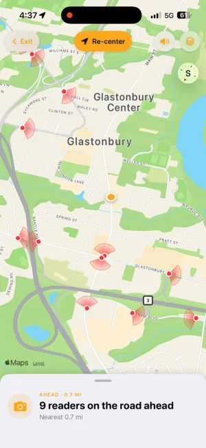
The Flock Camera app ships the whole dataset on-device. Open the Map tab, tap any pin, and you get the brand, the operator where it is recorded, the compass bearing, and the date the entry was last verified on the ground. Area Stats gives you a count and a brand breakdown for whatever region you are looking at — the same numbers you would get from a records request, without filing one.
Because the database is local, none of those lookups leave your phone.
Know before you pass one.
Flock Camera draws a view cone on every camera with a recorded bearing and warns you before you pass one. Free, with no account.

 Scan with your iPhone
Last reviewed 2026-08-15. Camera data © OpenStreetMap contributors (ODbL). Flock Camera is an independent project and is not affiliated with or endorsed by Flock Safety, Inc.